
Archive Catalog Record
Images
Additional Images [1]
Metadata
Title |
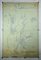
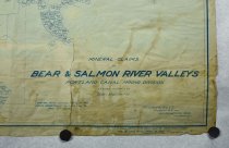
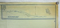
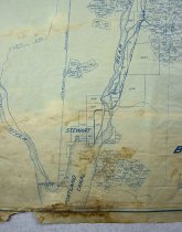
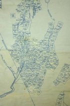
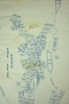
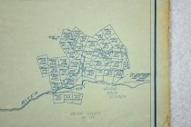
Mineral claims in Bear and Salmon River valleys Portland Canal Minning Division in the Cassiar District |
Object # |
94.2.39.1 |
Object Name |
Map |
Date |
1926 circa |
Creator / Author |
F.C. Green, B.C.L.S.; the Island Blue Print & Map Co. |
Publisher |
The Island Blue Print & Map Co. |
Area / Region |
Portland Canal Mining Division |
Description |
Mineral claims in Bear and Salmon River valleys Portland Canal Minning Division in the Cassiar District, B.C. Includes areas north of Hyder & Stewart; with claim borders, numbers and names; Note: map found in house at 2336 Fourth Ave., Ketchikan, Ak Victoria, B.C. Century - 20 Period - 1920'S Map reads: Mineral Claims In Bear & Salmon River Valleys Portland Canal Mining Division Cassiar District, B. C. Scale - 3000 Feet = 1 in. Compiled from surveys filed in the Lands Department, Victoria up to May 15th 1926 F. C. Green, B. C. L. S. Stewart, B. C. and 221 Pemberton Bldg. Victoria, B. C. |
Medium |
Paper |
Search Terms |
British Columbia Hyder Map Mineral Mining Mining Claims Portland Canal Stewart, B.C. |
Credit line |
Ketchikan Museums, KM 94.2.39.1 |